
How a Map Mistake Started a 30-Year High Altitude War War Between India and Pakistan (From “Overheard at National Geographic”)


Think about the state, territory or country you live in. How were the borders around it defined? Is it a geographic border or a political one? Are the lines straight or curvy? And what of those lines suddenly changed? That’s the topic of this week’s new episode of the Overheard at National Geographic podcast, titled “Unraveling a Mapmaker’s Dangerous Decision.” It explores the real-world consequences of a cartographer’s mistake, specifically pertaining to the map below.
(NDTV)
National Geographic writer Freddi Wilkinson, retired Pakistani army officer Abdul Rahman Bilal, director of cartography at National Geographic magazine Martin Gamache, Indian journalist Nitin Gokhale, and retired boundary analyst for the U.S. State Department Dave Linthicum are all special guests on this exciting episode. The border in question has sparked wars, people have died over it, until recently, it was a mystery as to how the border was drawn. But that’s jumping a little ahead of the story, which really begins following the events of World War II.
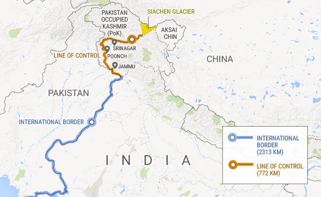
Under the rule of the British Empire, India and Pakistan were united. In 1947, with a collapsing economy, Britain made a hasty exit out of South Asia that caused chaos. Muslims in India were trying to get over to Pakistan, Hindus left in Pakistan were trying to get into India. An estimated two million people died in the process and in the end, both India and Pakistan believed that Kashmir belonged to them, starting an almost instant war that required the assistance of the United Nations. The solution was to draw a line through Kashmir, but the problem is that a high mountain range at the northernmost point of both countries was difficult to map at the time. A straight line measuring 40 miles was drawn up to the border of China to solve the dispute.
Flash forward to 1968 when the U.S. Office of the Geographer was asked by the U.S. Embassy in New Delhi to settle disputes regarding the Indian border, which included this 40-mile stretch through Kashmir. It was recently discovered that this is when Assistant geographer Robert Hodgson drew his new line, which mistakenly gave more of the land to Pakistan. Eventually, his new map was used as the basis for others, including those published by National Geographic, and that map ended up in India and Pakistan. Hodgson didn’t live to see the ensuing wars over a simple line on a map, having passed away in 1979.
By the way, this area with a simplified border is 4 miles above sea level, taller than the tallest mountains in North America, Africa, Europe, and Antarctica. The peaks have never been given names like “Everest” or “Matterhorn,” instead referred to by their height. You might think this area isn’t worth shedding blood over, especially since it takes skilled climbers to get to the glacial peaks, but that’s not the case.
In 1978, skilled military mountaineer Narendra “Bull” Kumar had been hired by some German adventurers as a guide through the region. That’s when he discovered their map, printed in the U.S., had a different border than the ones he was familiar with. He alerted the Indian Army who, upon discovering that Pakistan was already familiar with the new border, discovered teams of explorers in the remote area. By 1984, India had troops occupying several peaks, taking control of the Siachen Glacier. War ensued at one of Earth’s highest elevations where a lot of the deaths were caused not just by weapons, but also by complications relating to fighting in extreme conditions. With Pakistan holding the high ground on Peak 22,158, the war lasted for nearly 30 years.
Hodgson’s line has been removed and maps have been updated to reflect a newer claim that divides the area equally between India and Pakistan. Military forces still occupy both sides of the line, an event that all started through a mistake by a mapmaker outside the countries in 1968.
You can listen to this full episode and others at the official Overheard at National Geographic website.