Walt Disney World Weather Report for August 2 from @WDW_Weather


Emily's official track shifted a bit east this morning, but still needed to be watched. I will have a full tropical update at the bottom of this forecast.
What you need to know about today in a few words. Expect rain. As I said in yesterdays forecast - it's a certainty that showers will pop up it's just a matter of whether or not the parks will see it - well they did but thankfully storms came and went pretty quickly within an hour or so. There was more sustained rain over by Apopka but that's why it's so hard to forecast storms ahead of time this time of year - because as the crow flies ... that's right around the corner so to speak. So for today - there's more moisture to work with for storms today than there was yesterday so I expect even more coverage today. Storms will begin to pop up somewhere afternoon (I always like to say 2pm on days like this) and COULD last through sunset.
Lack of cloud cover and temperatures already in the 80s by 9am will lead to plenty of daytime heating. High temperatures will be in the low to mid 90s. Follow me on Twitter for up to date information throughout the afternoon (@WDW_Weather)...I realize there was some over-tweeting yesterday but trying to keep track of afternoon storms and tropical weather sort of demands it.
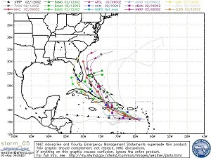
Now back to Emily - I had someone ask me last night if they should postpone a trip to Walt Disney World this weekend ... absolutely not. Emily is NOT impressive whatsoever this morning and really never has been. The storm is facing wind shear, dry air and is about to face some rather mountainous terrain. While the official forecast yesterday seemed to be pushing the track further west exactly towards Florida, this morning the track shifted East and now it looks like Orlando may be spared completely with maybe a little bit of rain. The problem is that because the circulation has been so disrupted, it's tough for the models to get on the same page with each other. One thing that has happened this morning is that the latest model run doesn't really even see Emily becoming a hurricane anymore - topping out as a strong tropical storm. A few of the models take Emily to her grave after interacting with land in a day or so. So long story short, there's a lot of uncertainty and if you are in Florida or planning on being there, just watch the storm closely ... we will know more in a day or two. That said I've attached the latest spaghetti models so you can see just how uncertain the track path is.